OVERVIEW | COUPLING | INTERFACE | DOCUMENTS | DOWNLOADS
interface
PIHMgis is an integrated and extensible GIS system with data management, data analysis, data modeling, unstructured mesh generation and distributed PIHM modeling capabilities. The underlying philosophy of this integrated system is a shared geo-data model between GIS and PIHM thus making it possible to handle the complexity of the different data models, representation structures and model simulations.
PIHMgis has been developed using basic QGIS source code. The GUI component of PIHMgis have been written in Qt, which is a cross-platform graphical widget toolkit and C++ while the algorithms and the hydrologic model PIHM have been coded in C and C++.
The interface is interactive and procedural. Figure shows a snapshot of PIHMgis interface. At each step, “Help” guides the user about the processes, the underlying algorithms, and provides guidance on selecting control parameters.
-PIHMgis Snapshot -
architectural framework
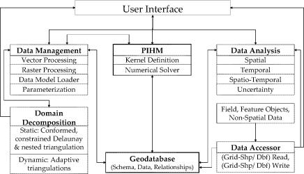
The architectural framework of the PIHMgis, as depicted in following figure, shows the functionalities and concepts inherent to it. The direction of arrows in Figure 4 indicates the possible flow of output from each of the functionalities. For example, the geodatabase gets enriched by the data-accessor or outputs from data-management or PIHM modules. The PIHMgis interface facilitates a range of potential to analyze like spatio-temporal statistics on outputs from the data-management module, raw data or enriched geo-database.
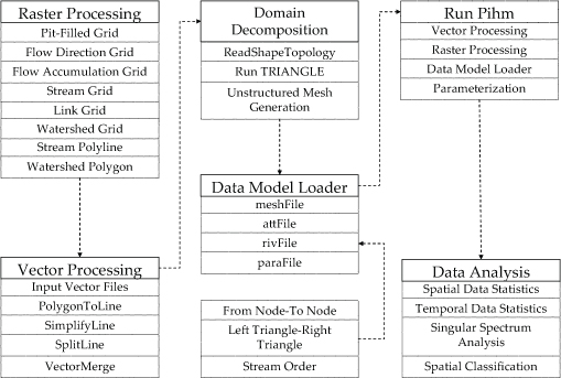
Procedural Framework
The procedural framework of the interface is shown in Figure. In the first step, raster-DEM-processing is facilitated for watershed delineation and stream definition. The Vector Processing module aids users in defining watershed properties and grid constraints using points (stream gauge, ground water observation-well locations), polygons (watershed and subshed boundary obtained in raster processing step, physiographic boundaries) and polylines (streams obtained from raster processing step). The domain constraints as well as internal and external boundaries are used to generate constrained Delaunay triangulations with certain restrictions on the minimum angle of each triangle. Before solving the finite volume based ODEs defined for each triangle, the respective forcing, soil parameters and boundary condition values are assigned in an automated way in Data Model Loader Module. Topology is used in PIHM to calculate the fluxes in and out of each mesh element. The parameters and topology embedded in the geodatabase, is shared by the PIHM data structure to support numerical calculations at each time step. Finally, statistical and other kind of data analysis can be performed on the model output using data-analysis module.